Here’s the real challenge when governments no longer control sensitive information. This opinion piece written by Theo Milonopoulos and Erik Lin-Greenberg first appeared in the Washington Post here.
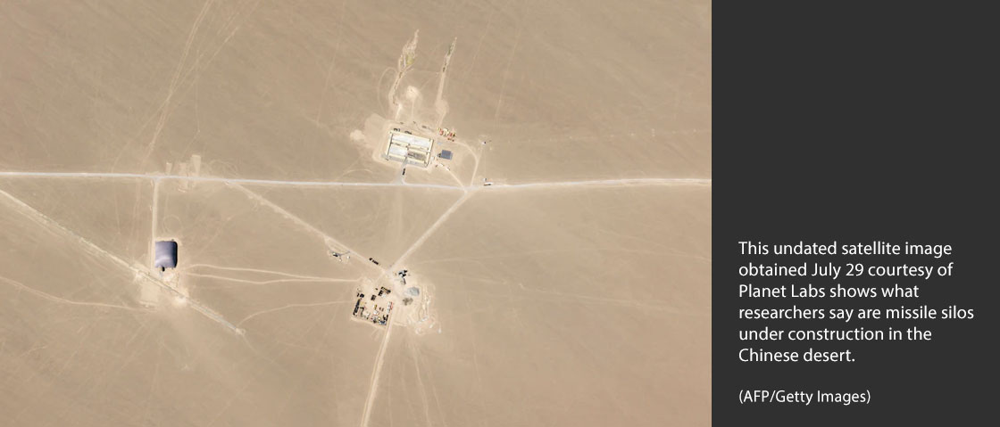
Last week, researchers at the Federation of American Scientists used satellite imagery to uncover more than 100 suspected nuclear missile silos under construction in western China. Days later, private analysts identified new underground facilities at a Chinese nuclear test site using similar satellite images.
These revelations, coming after the discovery of another Chinese missile field in June, leveraged satellite imagery to disclose some of Beijing’s most closely guarded secrets about its nuclear program.
But these images didn’t come from government intelligence agencies. Instead, they were collected using privately operated commercial satellites and analyzed at think tanks — no high-level security clearances required.
This is not how we used to find out about major national security secrets.
Once upon a time, such findings were almost exclusively in the hands of governments with robust intelligence organizations. The proliferation of commercial satellites has upended this near-monopoly on government intelligence gathering. And this also means leaders now have less freedom — both politically and strategically — to handle this kind of news.
Commercial satellites are like private eyes in the sky
Reconnaissance satellites offered a major advance in intelligence gathering, providing a bird’s-eye view of adversary military activities without risks to pilots. As Danielle Lupton wrote here at TMC, mobilization for the Allied forces’ D-Day landings in June 1944 would have been nearly impossible to keep secret in the satellite age. During the Cuban missile crisis, the Kennedy administration relied on spy planes and their pilots for information about Soviet missiles in Cuba — though overflight risks meant less reconnaissance. Government control over this information and imagery helped Washington keep the early days of the crisis secret, even during the 1962 midterm election campaign.
First introduced in 1960, reconnaissance satellites and their findings were once highly classified. Intelligence personnel analyzed satellite imagery, and government leaders decided whether and when to release it publicly.
Satellite imagery became more publicly accessible beginning in the 1970s as governments launched new satellite programs — like France’s SPOT and America’s Landsat. These provided images to researchers and other nongovernment users. ABC News, for example, used SPOT imagery to confirm the 1986 Chernobyl meltdown. These satellites, however, were limited in number, and imagery was often difficult for nonexpert users to access.
In the 1990s, private firms began launching their own satellites capable of generating high-quality images. The expense of these satellites, however, continued to limit their availability.
In recent years, technological advances, coupled with decreased launch costs, have accelerated the expansion of the commercial satellite sector. Today, private companies operate tens and hundreds of small satellites that deliver imagery to customers in near real-time. Planet, the company that provided the imagery on China’s missile silos, operates more than 200 satellites and claims that they capture “the whole Earth land mass daily.”
Private satellite imagery has been used to document a range of phenomena, from coronavirus lockdowns to China’s internment of ethnic minorities. Private companies have launched or plan to launch more than 700 imagery satellites in an industry whose market size is expected to double to $4.17 billion by 2027.
Governments have lost their information monopoly
The increased availability of satellite imagery has major consequences for governments. By using commercial satellite images to reveal information that was once kept under wraps, nongovernment groups can present governments with difficult decisions about whether, when and how to disclose covert activities taking place around the world.
And our research, published in a recent paper, demonstrates how commercial satellite images that disclose sensitive information can constrain governments considerably. They can expose contradictions between what leaders claim and the realities on the ground. They can also mobilize public pressure in favor of or against confrontational policies.
But governments adapt to changing circumstances. In some cases, governments may simply refrain from covert operations if they believe they will be caught by ever-proliferating information-gathering and communication technologies.
In other cases, they may try to leverage the new satellite reality by using the disclosure of sensitive information by nongovernment entities to advance their own interests.
After the latest revelation regarding China’s missile silos, US Strategic Command, steward of America’s nuclear arsenal, took to Twitter and all but confirmed what commercial satellites had revealed about Beijing’s nuclear ambitions.
Since the US government has far more advanced intelligence capabilities than commercial firms and think tanks, Strategic Command was probably aware of these missile sites long before the commercial imagery was published. So why refrain from revealing this information previously?
It’s possible Washington held off on identifying the new missile field to protect its intelligence sources and methods. Once nongovernment entities had made the information public, Strategic Command could confirm the revelation without exposing covert collection capabilities.
The decision to withhold evidence of China’s missile site construction before the publication of these images may have also been intended to avoid domestic pressure to escalate already confrontational relations with Beijing.
Did China want to get caught?
If Washington gambled that China’s activities might be revealed through commercial entities, what about Beijing’s thinking? Analysts speculate that China may have wanted these sites to be detected, perhaps as part of what nuclear weapons expert James Acton described as an elaborate “shell game” to obscure the true size of Beijing’s arsenal and complicate efforts to target Chinese missiles.
Even if Beijing did not want the sites to be disclosed publicly, commercial satellites effectively diminished what political scientist Austin Carson calls the “backstage” of covert military operations, where rivals use secret maneuvers hidden from public view to communicate their intentions without the risk of rallying their publics behind escalation.
What is clear, however, is that the availability of commercial satellite imagery allowed private organizations, rather than leaders in Beijing and Washington, to decide when and how to disclose information about China’s nuclear program.
As commercial imagery satellites proliferate in orbit, policymakers around the world will increasingly need to grapple with the ways the technology can reveal national security secrets. Although decision-makers can leverage these technologies for their own purposes, they may continue to find themselves pushed toward more confrontational policies if commercial imagery mobilizes public opinion.
Theo Milonopoulos (@MilonopoulosT) is a postdoctoral fellow at the University of Pennsylvania’s Perry World House.
Erik Lin-Greenberg (@eriklg) is an assistant professor of political science at MIT.